
Kaisadroupolis
Kaisadroupolis—the City of Bridges—is the cultural and scientific center of Jideran. Overlooking the Kelfidroga Strait, it is the most well known and arguably the most significant city in the Republic of Kaisa. History has played itself out in its web of interconnected isles, winding streets, and terraced walkways, and the weight of that history rests heavy on the shoulders of the city. The last decades have seen walls belonging to structures dreamed up by the most brilliant and inspired architects the world has ever seen pockmarked by firing squads, blood still staining the limestone.
During the Kaisan Revolution of 1333, the city was besieged by the Kaisan Army and Etnofroura. During the offensive that ended the commune, the army bombarded the city with artillery and bombs from aerostats and autogyros. Much of the city still carries scars from the shelling and the ensuing invasion.
From north to south:
History
Founding
Kaisadroupolis was established in 882, when the Argomaitian capital of Luaple was sacked by Stomma Eugenos the Second and reborn. Eugenos declared Kaisadroupolis to be the new capital of the Kaisan Stommatate, and for the next two centuries, the city enjoyed a golden age. The arts and sciences flourished, with such institutions as the Kaisan Academy of Metanatural Philosophy becoming established.End of the Stommatate
Kaisadroupolis became known as a center for culture and philosophy, and as the Age of Idealism began, Kaisadroupolis became a hotbed of radicalism. In 1099, the War of the Lion broke out, and Kaisadroupolis erupted into riots and chaos. When the war was over, the victorious Ilakidi Koudagaton and new ruling Symvouli Tiporé declared Chypos to be the capital of the new Republic of Kaisa.Revolution and the Kaisadroupolis Commune
Despite the capital being moved from Kaisadroupolis, the city remained the center of culture and politics in Kaisa. The 1100s and 1200s saw Kaisadroupolis continue to grow, exploding through the onset of industrialization and urbanization. As capitalism grew, the radical movements in the city continued to expand through the struggle of the dispossessed. Several small uprisings sparked and were dowsed, but there was a feeling in the air that the time would come. In 1333, when revolution broke out, many believed that time had arrived. The communist and libertarian labor movement erupted after the devastation of the Red Week, resulting in the creation of the Kaisadroupolis Commune. The commune kicked out the Etnofroura, National Police, and army and created an expirement in autonomy and social organization that has inspired people across Duurn. Their victory was short-lived, as the revolutionaries found themselves trapped and cut off from supplies. They held out as long as possible, but their hopes did not come to fruition. The revolution failed to take ahold in the rest of the nation, and eventually, the Army broke through. The forces of the Symvouli, including the echelarist gangs which hid when the revolutionaries took the city, raged through the streets, slaughtering any communist, libertarian, or union member that they could get their hands on. The radicals went to ground, but they continued the fight even through the White Terror that followed their defeat.The Last War and the Daffodils
The Last War, at first welcomed in a wave of nationalism, only further tore into the already deeply wounded city. The radical labor movement, driven underground after the 1333 Revolution, recouped from their losses and bided their time, all the while continuing to build behind the scenes. The federalist SEK-ESK, the largest labor federation in Kaisa, worked to reestablish their foothold in the city and the rest of the country. Late in 1349, a mutiny broke out among the Kaisan Army. A general strike broke out across Kaisa, supported by the SEK-ESK. By 1350, the Symvouli has declared martial law, but their control over the city is slipping as the Daffodil Revolution begins.Geography
Kaisadroupolis was built at the southwestern tip of the Gafinou Peninsula, stretching across the islands that dot the waters in and around the Kelfidroga Strait. Because of its position on the strait, it has become a major trade city at the intersection of Jideran and Vieluesse. The part of the peninsula that much of the city is built upon is close to sea level, with soft and silty ground. This has caused parts of the city to slowly sink over time, despite efforts to create stable foundations. Some parts of the city even experience flooding during high tide, necessitating the construction of barriers and diversion canals. Poor neighborhoods have simply been left to endure.Cityscape
The Metropole
Over time, the area called Kaisadroupolis has expanded and swallowed up many of the smaller towns and cities that surrounded it. Others remain legally distinct but have been folded into the Kaisadroupolis Metropole. The city proper is split into dimos, smaller administrative districts based on demographics, geography, urban planning principles, and historical connections.The Old City
Kaisadroupolis had its start in the Skosa dimos, where the historical capitol of the Stommatate was located. From there, the city expanded across the southeastern tip of the peninsula. The portion of the city made up of the six oldest dimos has become colloquially known as the Old City.From north to south:
Vieluessean Dimos
Gefyrapolis, on the Vieluessean side of the Kaisadroupolis Metropole, is dominated by manufacturing and industrial quarters. In contrast with the Jiderani side of the city, many of the residential buildings here were hastily constructed with cheap and easy materials as rapid urbanization took place. The lower durability of the construction meant that when the shelling of the city occurred in 1333 entire neighborhoods in the Vieluessean dimos were reduced to little more than piles of matchsticks. Much of it still has not been rebuilt, as other parts of the city have been a higher priority in the decade and a half since.East vs West
The city of Kaisadroupolis began on the eastern side of the tip of the peninsula, and to this day, the east is the dense urban center of the metropolis. As the city expanded, it grew to encompass several smaller towns on the western side, including Petroka and Chakismos. Still though, much of the western side of the city is less developed than the east, with much of it taken up by smallhold farmland, vineyards, and the sprawling estates of the wealthy in the Kofa dimos. Not all of the west is so economically well-off, however. The dimos of Synodera and Anovara are two of the poorest in the city.Construction
Much of Kaisadroupolis has been constructed using limestone bricks, a common material in the region. More modern materials, such as steel, are becoming more common in the newer districts of the city. In the poorer outskirts of the city, many buildings have been hastily constructed with wood to handle an influx of residents. In the core, historic parts of the city there are significant restrictions on materials, design, and planning. To mitigate the soft ground, buildings in the city are built upon slabs of limestone, with log piles driven deeper into the soil, until they reach harder earth. A network of canals has been dug throughout the city, in order to divert flows of water and for soil to raise the surrounding landmass. The canals are commonly used for transportation via small flat-hulled boats.Architecture
A person walking through Kaisadroupolis can trace its history through the changes in architecture. Some of the oldest buildings in the city were built as far back as the times of the Jiderani Empire or Argomaitian Empire, when the city was still Luaple. The western Jiderani styles of architecture from the imperial days have blended with regional architecture to create a style unique to Kaisadroupolis.Transportation
In the urban core of Kaisadroupolis, on the eastern side of the city, the streets are far too narrow and labyrinthine for motorcars to navigate easily, and the terrain is too hilly for bicycles to be reasonable. For day-to-day transportation, most people are able to walk wherever they need to go. Otherwise, streetcars connect most neighborhoods and even run between the eastern and western halves of the city. FInally, the networks of canals, built to divert water from flooding the city, are often used for transportation in the east via narrow, engine-powered boats. In the west, motorcars are more widely used, enabled by the lower density and wider streets. However, they are mostly individually owned by wealthier inhabitants. Most citizens use streetcars or motorbuses. Prior to the 1333 Revolution, an elevated rail system cut across the city from north to south. During the repairs following the bombardment, the rail system was expanded to include several connected east-west lines that create a loop around the metropolis.Maps
-
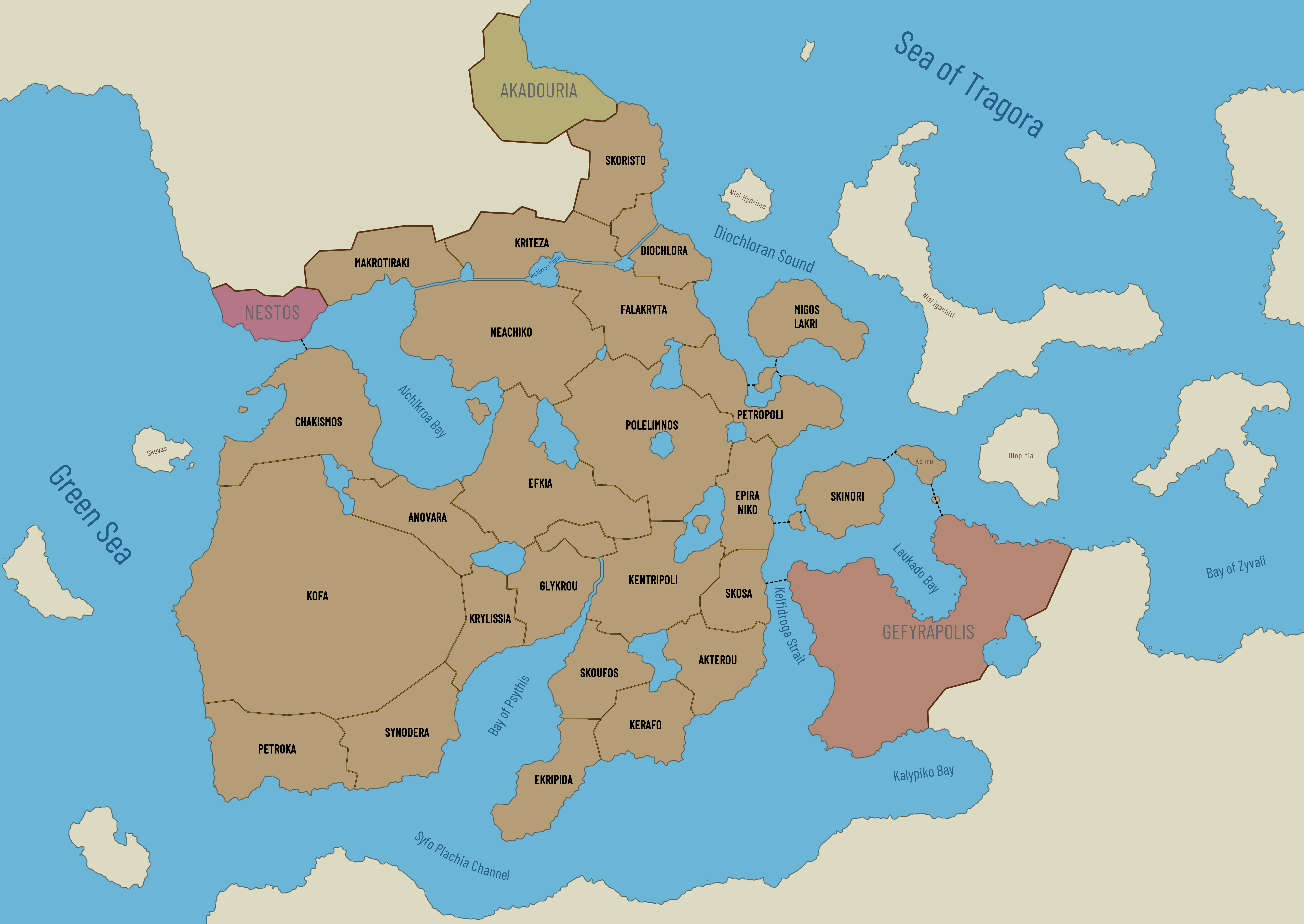
Kaisadroupolis Map
A map of Kaisadroupolis, including each of the dimos of the city, as well as the surrounding bodies of water and the locations of the major bridges.
Founding Date
882
Alternative Name(s)
The City of Bridges
Type
Large city
Location under
Included Locations
Owning Organization
Characters in Location
Remove these ads. Join the Worldbuilders Guild


Comments