Sunekan Shallows
South of the Sunekan heartlands, between the lands held by the religion known as the Suneka, is a great shallow sea many hundreds of miles across. These shallow seas are rich with aquatic life across a great continental shelf and make for easier sailing than in many deeper oceans. Leviathans avoid such shallow waters; sea monsters in this ocean are extremely rare.
While sea monsters are not common here, Cephapeople thrive in such shallow waters. Much of the shallows are controlled by the Undersea Sonoko Federation, though the Northern seas are controlled by the Shushunu Crablords.
The Totaken Canal, a large mechanical canal operated jointly by the Undersea Sonoko Federation and Oteka Republic, connects the Sunekan Shallows to the East Sunekan Sea Rim. Given this connection, the Sunekan Shallows have culturally, politically, and incorporated the nearby portion of the Sea Rim.
Geography
The Sunekan Shallows are over 1000 miles across West to East. The Western entrance to the shallows is 430 miles across, though the longest North-South section is around 1000 miles long as well.
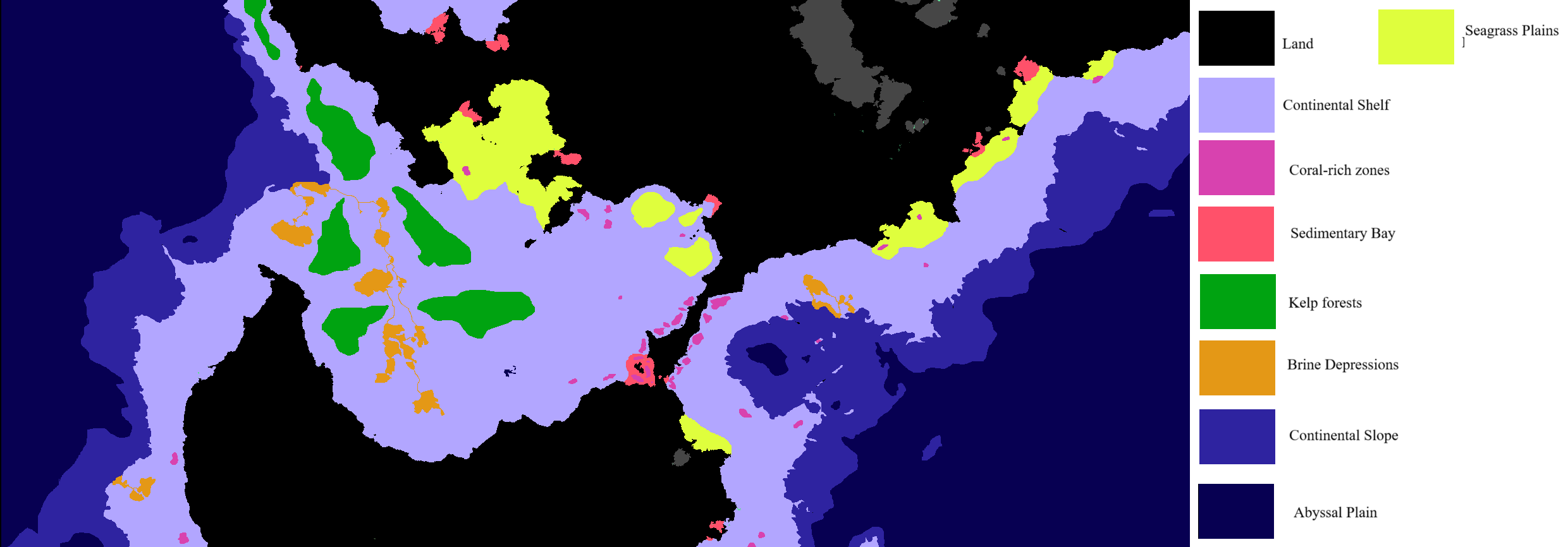
To understand the geography of this shallow sea, it is important to consider the ecological zones present in warm aquatic shallows:
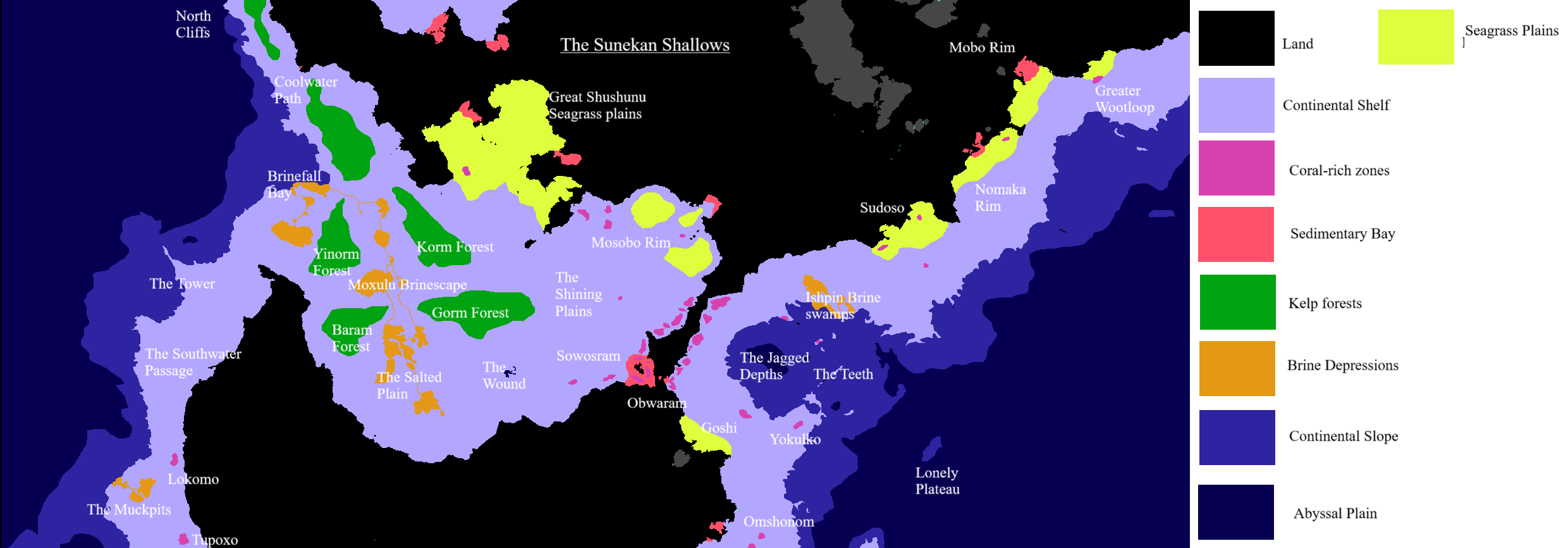
These regions are more than just their biomes: each region has a particular history and reputation for the people that live there. Putting names to these features makes them more recognizable:
Greater Sowosram is a reef-rich region all along the Western isthmus - forming a massive mega-reef strip in modern times, ruled by the reef-city of Sowosram. This is the political center of the Sunekan shallows and the most populous part of the Undersea Sonoko Federation.
Greater Obwaram is Sowosram's counterpart on the Eastern isthmus, under the rule of Obwaram reef. This reef is connected to Sowosram via the Totaken Canal.
The Mosobo Rim is another populous region under the control of Sonoko. This is a rich ecotone, where reef, seagrass meadows, and sedimented shallows meet, creating a bloom of ecological diversity. While less populous than the great reef strip of Sowosram, Mosobo a place where all kinds of aquatic species mix together. This is increasingly an important economic and political region for Sonoko.
The Shining Plains are a large sandy region with unusually high mica deposits in the sand - making it quite shiny. Also notable for the number of natural gas plumes here.
The Wound is an extremely deep chasm of unknown origin, infamous as a place where Crabcows fall and never return. Rumored to lead to supernatural places, the Wound connects to deep cavern systems. Generally understood as dangerous and frightening. Swift currents in and around the Wound push out plumes of sediment periodically like a geyser, and there may be volcanic activity deep in the caverns at the bottom of the wound.
The Salted Plain is a large, sediment-filled drainage basin where the sediment from the East slowly drains down into the brine rivers of the West. The Plain itself is not so intensely sedimented that it is poisonous, but the slowly rolling sediment and lower elevations make plant matter less common on the seafloor. Shellfish and crustaceans live in abundance here, though, and plenty of larger fish live here based on that ecosystem.
The Moxulu Brinescape is essentially a massive canyon between the major kelp forests, where the sediment from the Salted Plain flows out into the abyss. These dimly-lit rivers of poisonously condensed sediment are covered in a fine layer of clams, mussels, and other shellfish, as well as countless pieces of durable trash and wreckage that have slowly slid down into the canyon. The Brinescape drains out in a massive waterfall of condensed sediment and muck, called the Brinefall - centerpiece of Brinefall Bay, the cliff out into the abyss.
The four kelp forests - the Gorm, Korm, Baram, and Yinorm forests - are all known as a place of interest and community among Sentient Sharks. The Gorm forest has some of the most intensely developed shark settlements, with kelp supporting full structures and roadways. The Korm forest is known for being a bit wilder - some Starspawn live here with strange foreign animals and plants, and the forest has a violent reputation as a borderland between states. Still, Korm is fairly well-populated and is more "developed". The Baram forest is also known as the Hermit's Forest and has a bit of a lonely reputation as an isolated backwoods. Yinorm forest, meanwhile, is known as a bit haunted and spooky - it has a reputation for ties to Leviathans - but has developed its own roadways for trading caravans.
The Great Shushunu Plains is a massive elevated plateau of seagrass, with a large reef area inside. This is incredibly full of fish, crabs, lobsters, and sentient life - and is generally a well-insulated and lush cradle of life.
The Tower is a seamount - an underwater mountain - that connects to the continental shelf and sticks out over the abyss in a very dramatic fashion. Not very hospitable, but a notable landmark.
The Coolwater Path is the continental shelf rim leading up to the aquatic realms of the North. A cold current runs South, bringing cool water with it that deep kelp thrives on. This current also serves as a highway of sorts, bringing many Northern peoples and creatures along the coast down to the Sunekan Shallows. Many refugees and pilgrims from Stildane have marked a path along this current - seeking a home in distant Obwaram or the mellow shallows nearby. The Coolwater path is particularly dangerous near the Northern Cliffs, where the dropoff into the abyssal zone is extremely sharp and sea monsters are prone to wander.
While many Northerners stop their travels here at the shallows, merchants often follow that cool current further south down the Southwater Passage. Southwater is less rich with kelp than Cooldwater, and therefore far less dense in food and supplies, but is also safer. A long road along the passage connecting Yinorm forest down to Lokomo reef is a popular avenue for trade.
While technically parts of the Eastern rim, it is worth mentioning a few locations around Obwaram that have become part of the Shallows politically, culturally, and economically:
All along the Rim is the Warmgrass Path, a long continental shelf rim with a warm current running along it to allow for rapid travel. The Path's currents are easier to navigate going East-to-West but seasonally shift to allow rapid West-East travel as well.
The underwater hills of Goshi, near Obwaram, are home to both seagrass meadows and reefs. The terrain, flatter near the bay, quickly becomes a mix of rugged crags and verdant hilltops. The caverns and crags make for difficult crab-herding, but also make for excellent subterranean hideaways. The rugged terrain becomes more barren the further out one goes - but remains pretty jagged. The reefs of Yokulko, atop a small sea-mount (or large hill) are the central attraction of the rugged hinterlands. The choppy landscape of Goshi and Yokulko is said to be home to a notorious Ruxa named the Uninlova - a massive shadow man that emerges from the water during storms to apprehend and test ships - wrecking those that fail their arbitrary exams.
North of Goshi and Yokulko are the Jagged Depths: great rolling hills and valleys sharply declining down into a great pit and canyon. This abyssal plunge is home to particularly aggressive predatory fish (from barracudas to dolphinfish), making even the upper waters of the depths somewhat hazardous to an unsuspecting and unprepared Cephaperson. The bottom of the Jagged Depths contains numerous mineral deposits, though only a small handful of daring Cuttlefolk know this. The Ishpin Brine Swamps drain out into the Jagged Depths and Abyssal plain beyond. A number of Merfolk live in the depths here - part of a group of merfolk that migrated into the region and were hunted to near-extinction by the united cephapeople.
The Jagged Depths do not connect to the broader abyssal zone, but instead jut back up into The Teeth: a series of seamountains and crags that rise from the depths and serve as a partial wall between the Jagged Depths and the greater abyssal plains further East. Plenty of hunting-fish prowl these waters, just like in the Jagged Depths, but the elevated mesas have enough growth to maintain local populations of sentient life. A notable reef zone, lonely Holaho, sits on one of these mesas.
North of the Jagged Depths and Obwaram are a series of seagrass bays and reefs that form clusters of verdant life along the shelf. Sudoso, the furthwest West of these, is pretty well integrated into Obwaram's sphere of influence at this point; further East, the Nomaka region is formally federated with Obwaram but remains culturally independent. The Mobo Rim further out is deeply decentralized and is supposedly haunted by a great beast that the local Squiddles unleash on invaders - possibly some strange beast summoned by Tragedy Magic. While Sonokan aggression into the Mobo Rim has ended, the region is slowly being pulled in by raw economic gravity.
Beyond Mobo is the sovereign reef of Wootloop, which reigns of the surrounding region as a classic reef-city-state. Wootloop and its sister-city Kokodowa (further East) are known for their lucrative Chemical Weapons contracts with the Republic of Kiwa.
South of the Depths and Goshi is Omshonom, a large plateau with massive slopes and ridges - with impressive reefs on the crests of those ridges. Those reefs are notoriously independent, even as the local squid ranchers are drawn into the Sonoko federation; should the Sonoko expand East by force, it will be here. For now, Omshonom serves as a barrier between the civilizations of the Sunekan Shallows and the territory of those ruled directly by the mad Leviathan Elder Night.
- Continental Shelf describes all elevated aquatic terrain before the dropoff into the abyssal plain (a lower level of oceanic terrain beyond the reach of sunlight). The continental shelf is hardly "shallow" by human terms: the shelf on average goes down around 600 feet, deeper in many places further out. While generally a flat plane, the shelf slopes downward gently and has many hills and valleys. Some sections have a floor submerged in twilight (so deep that the sunlight is dim) but none are fully abyssal (with no traces of even very dimmed light).
- Coral Rich Zones describe shallows with frequent reefs - which make for perfect reef cities if gardened and expanded by Octopersons. Even when this is not the case, these are regions with rich biodiversity, tons of local shallow-water fish, and many corals.
- Sedimentary Bays are contained shallow regions that receive drainage waterflow from surface regions, bringing rich freshwater algae and land sediments into the briny sea. Sedimentary bays are rich with sealife but can be difficult for corals to grow in (with some notable exception) - unless the seafloor drains well, it can be easy for the incoming sediment to cloud the lower waters, smothering light-dependent life. Shellfish and Giant Lobsters thrive in these regions.
- Kelp Forests are regions of intense kelp activity, where long strands of kelp reach from the depths up to the surface. Many species live in the kelp, creating abundance on par with reefs. While many aquatic regions, especially cooler ones, have multiple kinds of kelp forest (shallow versus deep), there are only deep kelp forests here. These kelp forests emerge from near-twilight depths and are simply enormous in their height. Despite their size, they are ecologically very fragile.
- Brine Depressions are cracks, depressions, and fissures in the shelf that collect sinking brine and sediment flows in such concentrations that they choke and smother fish and other gill-dependent creatures. Brine depressions almost seem to flow with cloudy water, forming lakes and rivers at the bottom of the sea. The heavy brine serves as food for numerous shellfish, which thrive in the low-predation environment. Most other life avoids these depressions.
- Seagrass plains are shallow sections of shelf that are coated in seagrasses: basically a kind of small, kelplike plant that grows like grass on the sea floor. These plants thrive in particularly shallow, sandy waters that are fed by sedimentary bays or other flows of surface nutrients. While most seagrass plains are still not "shallow" for landlubbers, they are still reliably shallow enough to get unfiltered sunlight.
- Continental Slopes are sharp declines from the Continental Shelves, where they go down into the Abyssal Plain. These slopes usually take the form of ridges, with hills and valleys of rock and sediment. Much steeper in decline than the shelf, the valleys of the slopes have dimmed sunlight and the hills are hardly shallow at their peaks.
- The Abyssal Plain is a blanket term for the deep ocean, where the bottom regularly is too deep for sunlight to reach. Hardly a plain at all, really, with plenty of mountains, valleys, hills, canyons, etc. Often imagined as bottomless by many surface and aquatic folks alike. The favored environment of Leviathans
Politics of the Shallows
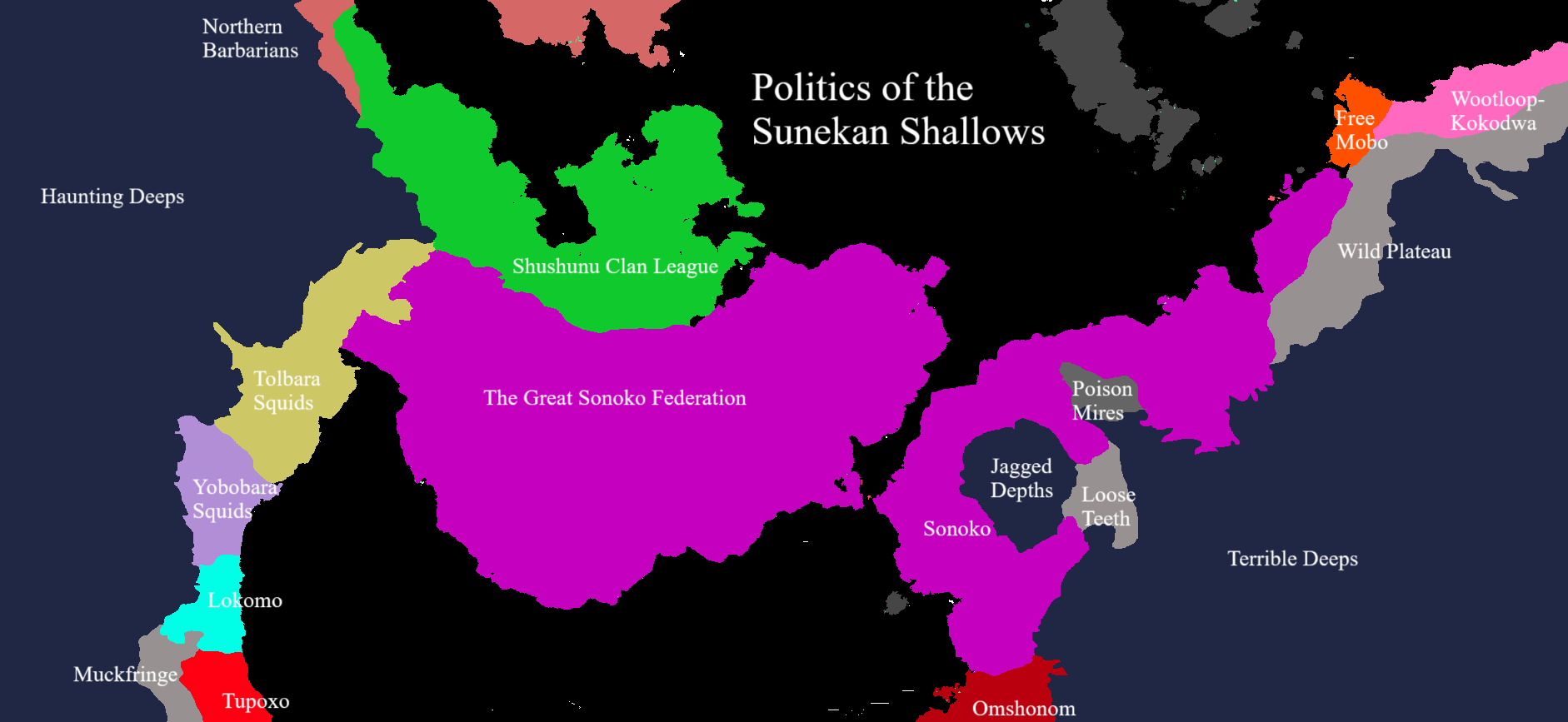
The Aquatic peoples of the Sunekan Shallows have their own political maps - in fact, they are much more territorially-minded than most other aquatic nations.
This map is not necessarily complete - there are territories between sharks, cuttlefolk, and leviathans in the deeps that are ignored here, and the "Northern Barbarians" are certainly not a cohesive whole.
Generally, this map is relevant for discussing the power of the region's central player: the Undersea Sonoko Federation. The Sonoko Federation is a grand republic styled as the undersea Suneka, which rules a massive trading empire and one of the most developed parts of the Eastern oceans. The Sonoko seek to use soft power (and sometimes direct force) to spread their influence and territory ever-further; they are inclusive of all aquatic peoples as long as they accept Sunekan religion. Sonoko's great rival is the Shushunu Clan League, also known as the Crablord Kingdom, a theocratic monarchy that was once the pre-eminent power of the shallows.
Other powers such as the Tolbara and Yobobara squids or Free Mobo are not really states so much as they are culturally similar bands of local people. The Poison Mires, Loose Teeth, Muckfringe, and Wild Plateau are all mixed regions with small populations and no notable local power structures.


Comments