Elsir Vale
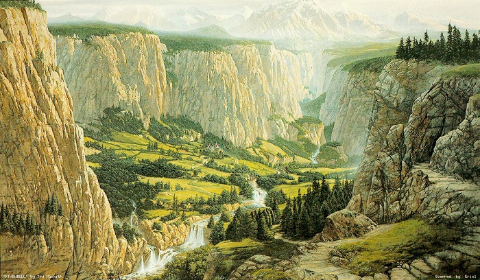
The setting of this adventure is a thinly populated human frontier known as The Elsir Vale and the surrounding wilderlands. The vale stretches almost 250 miles east to west and averages about 70 miles north to south. Several small mountain ranges and dense forests form the vale’s borders.
Climate and Terrain
Elsir Vale lies in the subtropical latitudes. Summers are hot and dry (although punctuated by the occasional intense thunderstorm), and winters are warm and rainy. Large stretches of the area are quite arid and the vale is flanked by vast savannahs stretching for mile after dusty mile. The forests that stretch across most of the vale’s northern reaches are stifling and swelling hot in the summertime, with not a breath of wind to relive the oppressive heat.
Ancient History
The scattered human towns and villages of the area grew up along the Dawn Way, an important east-west trade road linking the heavily settled lands that lie northwest across the Endless Plains with the exotic kingdoms and goods of the coastal lands lying to the southeast. Much of the Dawn Way was built by an ancient dwarf kingdom of Kho-Tharkk that spanned the Wyrmsmoke and Giantshield Mountains more than two thousand years ago. While the dwarves are long gone, their roads, bridges, and cisterns remain in use to this day. After the dwarf realm passed, the presence of various monsters and raiders kept traffic along the Dawn Way light for many years; few caravans dared the long and dangerous trek. Few humans lived in Elsir Vale during those years-only scattered settlerments of druidic folk who left behind little more than grassy barrows and Stone circles on the hilltops.
About six hundred years ago, the nearby city of Rhest came to control the vale and a large swath of land north of the Giantshields as well. Soldiers from Rhest secured rhe roads all the way to Dennovar and beyond, creating a safe passage for trade. More and more traders traveled the Dawn Way, and the kingdom of Rhestilor grew wealthy on the tariffs exacted from the passing merchants. Under the kingdom’s shield, the towns along the Dawn Way-Brindol, Talar, Terrelron, and the rest-grew up from tiny hamlets to flourishing human settlements
The kingdom of Rhestilor eventually collapsed under civil strife, monstrous incursions, and magical blights. Almost two hundred years ago, the city of Rhest was overrun by strange creatures from Lake Rhestlin. Although the warriors of Rhestilor killed many of the aberrations and their kind, the city was abandoned and the already weakened kingdom broken. The locks and canals surrounding Rhest fell into disrepair, and the Blackfens swallowed the ruined city (The Rise and Fall of Old Rhest and Rhestilor).
In the years since the kingdom’s fall, the towns of Elsir Vale have come to look after themselves. Most of the local lords, such as Jarmaath of Brindol, still hold rule derived from the old kingdom of Rhestilor. While everybody knows that the kings of Rhestilor are long dead, no new realm has arisen in the vale.
Recent History
The Red Hand of Doom
Forty years ago, a massive hobgoblin horde that was fanatically devoted to the dark goddess Tiamat and led by the charismatic half-dragon warlord Azarr Kul attempted to take over the entirety of Elsir Vale. Their conquest plans were eventually thwarted by an adventuring band known as the Tooth and Nail Brigade that were able to muster the inhabitants of the Vale, battle hobgoblins, giants, and dragons, and route an overwhelming enemy.
Geographical Regions
Blackfens
Lake Rhestin’s eastern shore is hard to define, because the lake gradually gives way to a vast wetland known as the Blackfens. The Blackfens tend to be marsh, rather than swamp-that is, most of the landscape is a treeless maze of open water, reeds, and wet, grassy flats that shelter countless waterfowl. Isolated hummocks or islets in the marsh are covered with dense brush or forest. In the days of Rhestilor the marsh was much smaller, its spread controlled through locks and canals, but it has grown steadily since the kingdom’s dissolution. Half-drowned farmhouses, dilapidated barns and sheds, and sinking fieldstone fences tell the tale of settled lands slowly inundated and abandoned.
The Dawn Way
About 20 miles north of skull Gorge, the Dawn Way splits into the Old North Road, which leads up along the western shores of Lake Rhestin to the Endless Plains and the cities to the north and the Dwarf Road, which climbs through the Wyrmsmoke Mountains to the lands of the west. Once this road was the preferred route for caravans traveling east-west, but the growing presence of savage tribes and hungry monsters in the Wyrmsmokes led to the Dwarf Road being all but abandoned. Most travelers follow a battered cart track that parallels it 30 miles farther north or take their chances on a track skirting the Thornwaste to the south, steering clear of the goblin infested mountains.
Elsir River
The major river of the region is the Elsir, a broad but slow-moving stream fed by a number of tributaries. For most of its length, the Elsir averages 200 to 400 yards in width, reaching depths of 20 to 40 feet in the middle of its channel. The small town of Elsircross, about twenty miles upstream of Brindol, is the first place where it can be forded, although a wooden bridge spans the river at Brindol and ferries cross it at Talar and Drellin’s Ferry.
Endless Plains
North of the mountains at the edge of Elsir Vale lies a great windblown sea of dry grass, stretching for hundreds of miles east, north, and west. The plains aren’t truly featureless, the land has a fair amount of rise and fall, and low-lying creek beds choked with undergrowth and briars that cut deep gullies throughout the grassland. Lonely stands of frail, narrow trees dot the savannah. Nomadic human barbarians, tribes of gnolls, and bands of wild centaurs roam the Endless plains.
Giantshield Mountains
Sheltering Elsir Vale from the harsh weather of the Endless Plains, the Giantshield Mountains are a low range of arid, well-weathered peaks. The northern slopes are barren, dry, and rocky, home to a variety of dangerous monsters. The southern slopes are a little more hospitable, covered in light pine forest and cut by the gorges of many small seasonal streams. A smattering of isolated farms and steadings hidden throughout the southwest portion of the range represent the last remnants of the druidic folk who once lived throughout the vale.
Golden Plains
East of Elsir Vale lies a vast, arid steppeland that quickly gives way to rocky desert. In the vicinity of Dennov, the Golden Plains are dry, flat grassland, but within a few dozen miles the grass gives way to a rock littered badland of flats and mesas a waterless and inhospitable wilderness posing a formidable trial for the trade caravans following the Dawn Way.
Lake Rhestin
This shallow, marshy lake stretches almost 100 miles from north to south. Once its shores were dotted with the villages and manors of Rhestilor, but in the centuries since the kingdom’s fall, humans have largely abandoned the old heartland of the realm.
Marth Forest
Climbing the southern Foothills of the Giantshield Mountains, Marth Forest is a rugged, wild woodland rarely trodden by human feet except in its southwestern fringes. In its lower reaches, the forest is dotted with the old barrows and stone circles of the ancient druidic folk who once dominated the vale. The higher parts are home to goliath barbarian tribes, disorganized clutches of feral berserkers rarely encountered outside the woods.
Orc Country
The region that the Orc Tribes wanders is called Garmadh, but to the rest of the vale it is simply known as Orc Country . The image painted of Garmadh in stories and novels is one of a shadowy, desolate wasteland, paradoxically both devoid of life and overrun with a black-skinned orcish horde, consumed with rabid infighting when they are not raiding trade caravans and human settlements.
Racist overtones aside, Garmadh is made up of five smaller regions tucked behind the Stonehome Mountains. All of these regions are varying degrees of arid, all are quite different from one another, and all are absolutely teeming with flora and fauna. Moreover, Garmadh is home to dozens of different orc tribes and ethnicities, all of which are themselves comprised of hundreds of clans.
Stonehome Mountains
Overlook is one of the most interesting features of the Stonehome Mountains, but it isn’t the only one. Ruins of the old dwarven kingdom dot the peaks for hundreds of miles north and south, while old caves lead to tunnels worming through the rock. Closer to Overlook though, the land is safer and is home to numerous villages and other places of interest.
Thornwaste
South of the Wyrmsmoke Mountains lies a vast barren land known as the Thornwaste. A maze of broken hills, briar-choked ravines, and dry, dusty scrubland, these bad lands give way to larger and larger stretches of true desert as one goes farther south and west.
Westdeep
Several xenophobic tribes of wild elves dwell in the depths of this dense forest, avoiding contact with most other folk. The elves of the Blackfens once counted themselves among these folk, centuries ago they broke ties with the Westdeep elves and struck out to the east, eventually settling in the Blackfens.
Witchwood
Generally held to be haunted by the restless spirits of the ancient human druidic folk who once dwelled here, the Witchwood is a lush, wet woodland interspersed with swampy stretches in the vicinity of the larger rivers.
Wyrmsmoke Mountains
Several volcanic peaks gave this rugged range of hills and low mountains its name; travelers who observed the plumes of ash and smoke that sometimes arose from the inner hills believed that a great red dragon was responsible for the fuming hills. The Wyrmsmokes are home to a number of goblin, hobgoblin, and bugbear tribes.
Wyvernwatch Mountains
South of Elsir Vale lie the Wyvernwatch Mountains, a forbidding range of high, steep mountains with few passes leading to the other side. The Wyvemwatches divide Eisir Vale from the more densely populated and civilized realms of the southern coast. Only the most determined trekkers cross this range; most go hundreds of miles to circumvent east or west around the mountains before turning north.
Wyvern Tor
This crag is a prominent landmark in the rugged hills east of the Stone Home Mountains and is easily visible from 20 miles away. People traveling along the Triboard Trail in the vicinity of Conyberry catch glimpses of Wyvern Tor as they go. The Tor was formerly home to a large nest of wyverns, but a group of adventures known as the Landstriders dealt with the monsters years ago.
Sites of Interest
Clan Halls
These empty caverns were once a part of the ancient dwarven kingdom. It’s anyone guess as to what denizens now call this place home.
Conyberry
The town of Conyberry was sacked by orcs many years ago when the Kingdom of Rhestilor fell and now lies in ruins. The Triboar Trail runs right through the abandoned town.
Thornwatch
Built thousands of years ago by the dwarves, Thornwatch is a ruined watchtower that now consists of little more than a few crumbling walls and the broken stump of a tower, destroyed when the Kingdom of Rhestilor fell. In the tower’s courtyard stands an old well that still delivers clean fresh water.
Rhest
Once a prosperous city and capital of the kingdom of Rhestilor, Rhest is now a half-drowned ruin slowly sinking in to the Blackfens.
Thundertree
Once, this was a prosperous community on the outskirts of the forest, wealthy from the work of its woodcutters and trappers. Then about 40 years ago, orcs from the Orc Wastes destroyed the village during the Doom invasion.
Spirit Guard
Spirit Guard is a tower encased from top to bottom in a shimmering cocoon of solid ice. As one approaches the tower it becomes unnaturally cold and sudden blizzards flare deterring all but the hardiest travellers. It’s rumoured that the exterior stone of of the tower is carved to show various devils in flight, as if a huge swirling column of fiends had erupted from deep within the earth and was being pulled into the heavens.
Bordrin’s Watch
Bordrin’s Watch was built after the orc incursion of the vale forty years ago around the same time Overlook was establish. It guards the lone passage through the Stone Home mountains that orcs might use in another attempt at invading the vale.
Fort North Hill
Built hundred of years ago by the Kingdom of Rhestilor, Fort Northhill once housed soldiers who patrolled the northern borders. It now lies abandoned but completely unmarked by war as the soldiers were called away in desperation to help defend the vale from the orcs to the south and west.
Endlewatch
Built thousands of years ago by the dwarves, Endlewatch is an abandoned watchtower that now consists of little more than a few vine covered walls, abandoned about 200 years ago when the Kingdom of Rhestilor fell.
Token Vigil
Far south, in the remote Ealatos Plains lies the monastary of Token Vigil. Supposedly housing a great library of books, the monks who live here are hardly seen outside it walls.
Civilizations
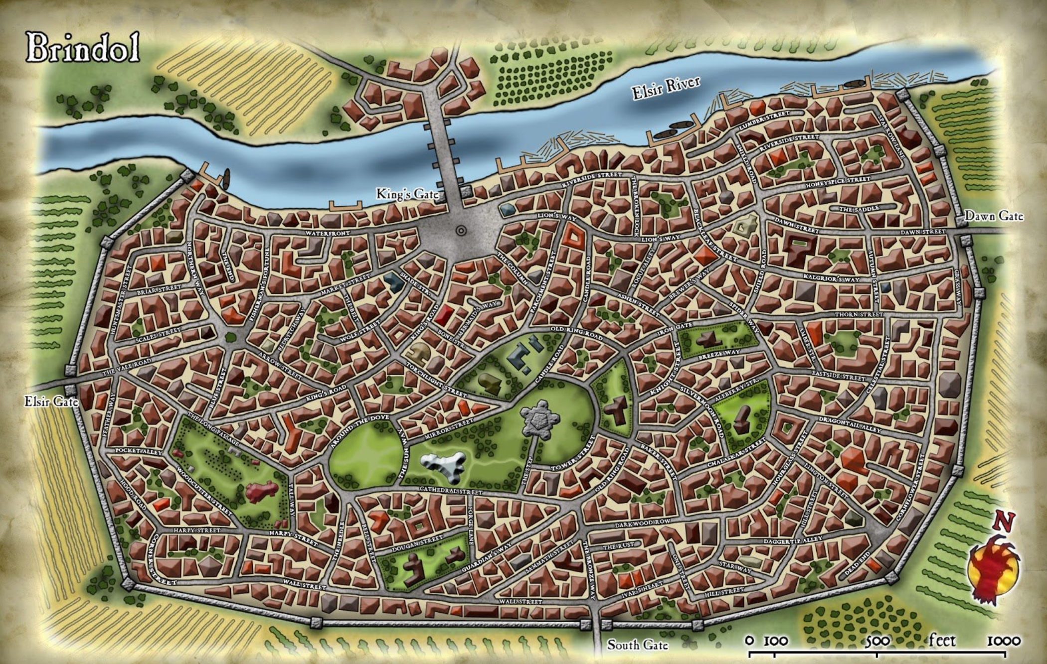
Brindol
- Population: ~6,000
- Significance: Largest and most influential city in the Vale.
- Features: Walled city, seat of the Council of Elders. Boasts a college, wealthy districts, and a fortified keep.
- Notable Events: Defended valiantly during the Red Hand invasion.
- Tone: Politically tense but hopeful; bastion of civilization.
Overlook
- Population: ~8,000 (mostly dwarves and humans)
- Location: Western edge of the Vale, at the foot of the Stonehome Mountains.
- Purpose: Defensive stronghold guarding the Monastery of the Sundered Chain and The Westdeep.
- Tone: Stoic, martial, and industrious.
Drellin's Ferry
- Population: ~900
- Location: Western Elsir River, near the Witchwood.
- Features: A frontier trade town with a ferry crossing the river.
- Events: One of the first casualties of the Red Hand invasion.
- Tone: Rural and vulnerable, represents the Vale’s outer rim.
Talar
- Population: ~1,200
- Location: Eastern Vale, on the Dawn Way.
- Significance: Market town and minor trading hub.
- Tone: Idyllic but fragile.
Dennovar
- Population: ~5,000+
- Location: Eastern border of the Vale, near the lake.
- Culture: Wealthy, mercantile, with strong noble families.
- Military: Private militias, limited official army.
- Tone: Political and refined, sometimes aloof from Vale affairs.
Hammerfast
- Type: Dwarven stronghold
- Location: Southern mountains
- Significance: Center of dwarven tradition, crafts, and defense.
- Tone: Proud, ancient, and closed to outsiders.
Elsircross
- Population: ~1,500
- Location: Central Vale, east of Brindol
- Purpose: Military outpost and river crossing.
- Role: Acts as a fallback defense point if Brindol falls.
- Tone: Functional and martial.
Marthton
- Population: ~700
- Location: Northern edge of the Witchwood.
- Culture: Woodcutters, hunters, and those wary of fey influences.
- Tone: Mistrustful, superstitious, and isolated.
Red Rock
- Population: ~500
- Location: Southern border, desert edge.
- Economy: Gem and ore mining; rough frontier justice.
- Tone: Harsh, independent, and rugged.
Prosser
- Population: ~300
- Location: Near the western edge of the Vale, south of Drellin’s Ferry.
- Traits: Farming and livestock; wary of Witchwood creatures.
- Tone: Sleepy and conservative; ideal for eerie events or fey interactions.
Terrelton
- Population: ~600
- Location: Along the Dawn Way, between Talar and Brindol.
- Economy: Tannery and leather trade; notable for its strong smells.
- Tone: Gritty and unfriendly; townsfolk are known for holding grudges.
Nimon Gap
- Population: ~450
- Location: In a pass south of the Wyrmsmoke Mountains.
- Purpose: Guardpost settlement; scouts watch for hobgoblin movement.
- Tone: Militant and wary, feels like a town waiting for war.
- Role: Minor village, strategic for controlling movement through the vale.
Little Port
- Population: ~500
- Location: East of the Vale, by the Crent woodlands
- Features: First point on contact from travelers coming from the Golden Plains.
- Tone: supports tourism, trips out to Spiritgard.
Hillwatch
- Population: ~350
- Location: On the fringes of the Giantshield Mountains.
- Purpose: Watchtower community against giantkin or ogre raids.
- Tone: Isolated and vigilant
Dunes End
- Population: ~200
- Location: South of Overlook, near the Thornwastes.
- Traits: Dependent on trade caravans, water from rare desert springs.
- Tone: Isolated, dust-worn, resilient.
South Glade
- Population: ~250
- Location: South of Dennovar, near trade routes to distant lands.
- Features: Border town with foreign traders and smugglers.
- Tone: Cosmopolitan for its size; tense over trade politics.
Witchcross
- Population: ~150
- Location: Border of the Witchwood.
- Features: Half-abandoned; surrounded by fey activity and strange phenomena.
- Tone: Haunted and mysterious.
Dauth
- Population: ~500
- Location: South of Brindol on a branch of the Dawn Way.
- Features: Waystation and horse market.
- Tone: Rustic, friendly, often visited by travelers.

Comments