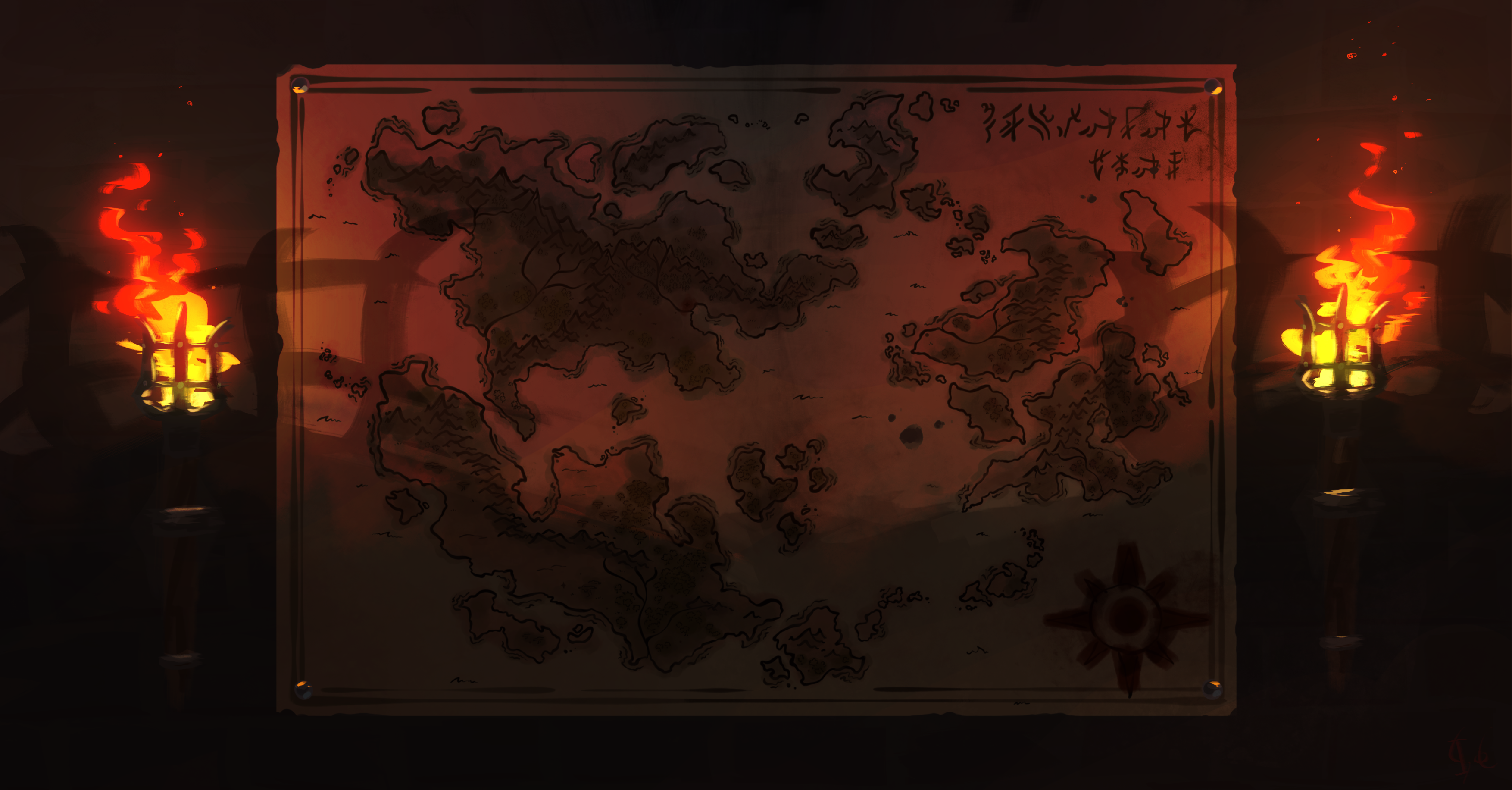
The First True Map
"...And so for all the the Argòxns that lay dead, all the warriors forged anew, and all the soldiers that wander aimlessly in foreign land, I mark this creation with my blood, a sacrifice so small compared to theirs."
The result of a 100 year campaign stretching across the known world, the First True map was the most ambitious search for knowledge of it's time. It was the first map to record the accurate layout and location of almost every landmass in Mortagan Skal.
Document Structure
Publication Status
Originally, the First True Map was a fiercely protected secret in order to keep the edge it gave Argòx over their enemies, and so copies provided only to the highest ranking tacticians of the Argòxn military. However, rumors of the map's existence began to spread across the empire, originating from soldiers who were on the campaign. Eventually, the Scol Leader at the time decided to confirm the rumors in a speech glorifying the campaign and the soldiers, hoping to intimidate Argòx's enemies with their newfound knowledge. The contents of the map still remained hidden.
Eventually, cartography in other nations caught up to Argòx's innovations, copies of the map found their way to the tables of increasingly lower ranking tacticians, and finally into civilian hands.
The original map is kept locked away in the archives of the fortress of Argòx-Arur.
Historical Details
Background
With the recent invention of black powder weaponry, the Argòxn Empire were raring to expand their territory past the ancestral lands of the Argòxn tribes. The tacticians and cartographers had a basic lay of the land, outside of Argòx, thanks to maps from foreign merchants, however, these basic and scattered pieces of information were practically useless for the Warmakers. Eventually, it was decided that a campaign would take place all over Mortagan Skal to scout out the unknown lands, and create a map to record it all. This campaign would span years, and would occur alongside the expansion of the empire.
History
100 Long Years
The campaign started in the capital, Argòx-Arur, with multiple brigades sent out at once. The best cartographers in Argòx were selected to record the coastlines on the long voyages out, and pre-existing regional maps were referenced for the mainland of each region. These brigades would bring the pieces of the maps back to the capital, where they were kept safe, and eventually pieced together and copied onto the main map.
On the Other Side of the Mountains
The lands of Calinderva were some of the hardest to record. The two empires had a long history of hatred for one and other, and so sending out scout ships and trading with them was out of the question. As their greatest and closest rival, Argòx also didn't want Calinderva to figure out what they were trying to achieve. Argòx decided that cunning was the best way to proceed, and through the use of spies, they succeeded in mapping out the Dervan lands.
The Ice that Lay Above
One of the most deadly parts of the campaign took place in the lands above Argòx, which were frigid territories that belonged to a nation that had invaded them many years ago, before the Argòxn tribes were even united as one. The combination of the inhospitable environment and hostile nation recording the lay of the land extremely difficult. Ice in the oceans slowed and sank ships, and the scouts sent out on the shore would often freeze to death.
Eventually the areas were mapped out, but not in great detail, nor without suffering heavy losses, including the death of one of the best cartographers in the nation.
And the Sand that Lay Below
Thankfully for Argòx, the coastline of the Varucan continent was already heavily recorded. Argòxn ships had already been coming and going from northern Varuca for trade for many years. Very few cartographers were sent out, and those that were only had to refine what had already been established. The mainland of the continent however, remained largely unmapped, thanks to the hot conditions that were new to the soldiers of Argòx. Regional maps from Varucan cartographers were heavily relied upon when recording this area.
Heat of jungles
The Ama'tairan islands just east of mainland Varuca were simple for Argòx to record. Just like the coastline of the mainland, these isles were already heavily mapped by locals, and with Ama'taira being a trading spot for merchants across Mortagan Skal, Argòxn ships were left alone by locals.
The Isles Across the Sea
The lands of Aao were the latest addition to the map, and proved a difficult region to record. During the time of the campaign, Aao was already at war with forces from within, so sending out military brigades to map the mainland and coastline would be unwise, and so Argòx chose a more peaceful approach, but this came with its own difficulties. Though maps from locals already existed, many were more abstract and only easily understood by the people of Aao. In fact, some Argòxn cartographers found themselves copying the layout not from these sketches, but from the descriptions and memories of village elders, who seemed to know the lands by heart. Much of the details of the lands of Aao are still unknown to Argòx.
Commemorated in Blood
In order to honor the many soldiers who lost their lives in the campaign to create the map, the main cartographer of the final map, Kressis Otohc, shed his own blood during the unveiling ceremony, using it to paint the compass and mark the location of Argòx-Arur.
Public Reaction
When the map was eventually spread to the public, it soon became a symbol of Argòxn might and prowess. More and more copies of the map were made, some even sewn into tapestries. Otohc's act of painting the compass in his own blood was replicated with each new copy, a tribute from each artist to the sacrifices made by the soldiers that died not only to create the map, but any that died to further the aims of the Empire.
Legacy
The map has proven to be one of the most influential things in Argòx's ongoing invasion of the various regions of Mortagan Skal. Before its creation, most maps were not particularly useful in strategic situations, and instead were inaccurate, abstract or spiritual, or focused more on aesthetics rather than giving information. And while accurate cartography was steadily improving, the first map of Mortagan Skal allowed it to soar. Most modern regional Maps made in Argòxn are based heavily on this map.
The First True Map


Comments