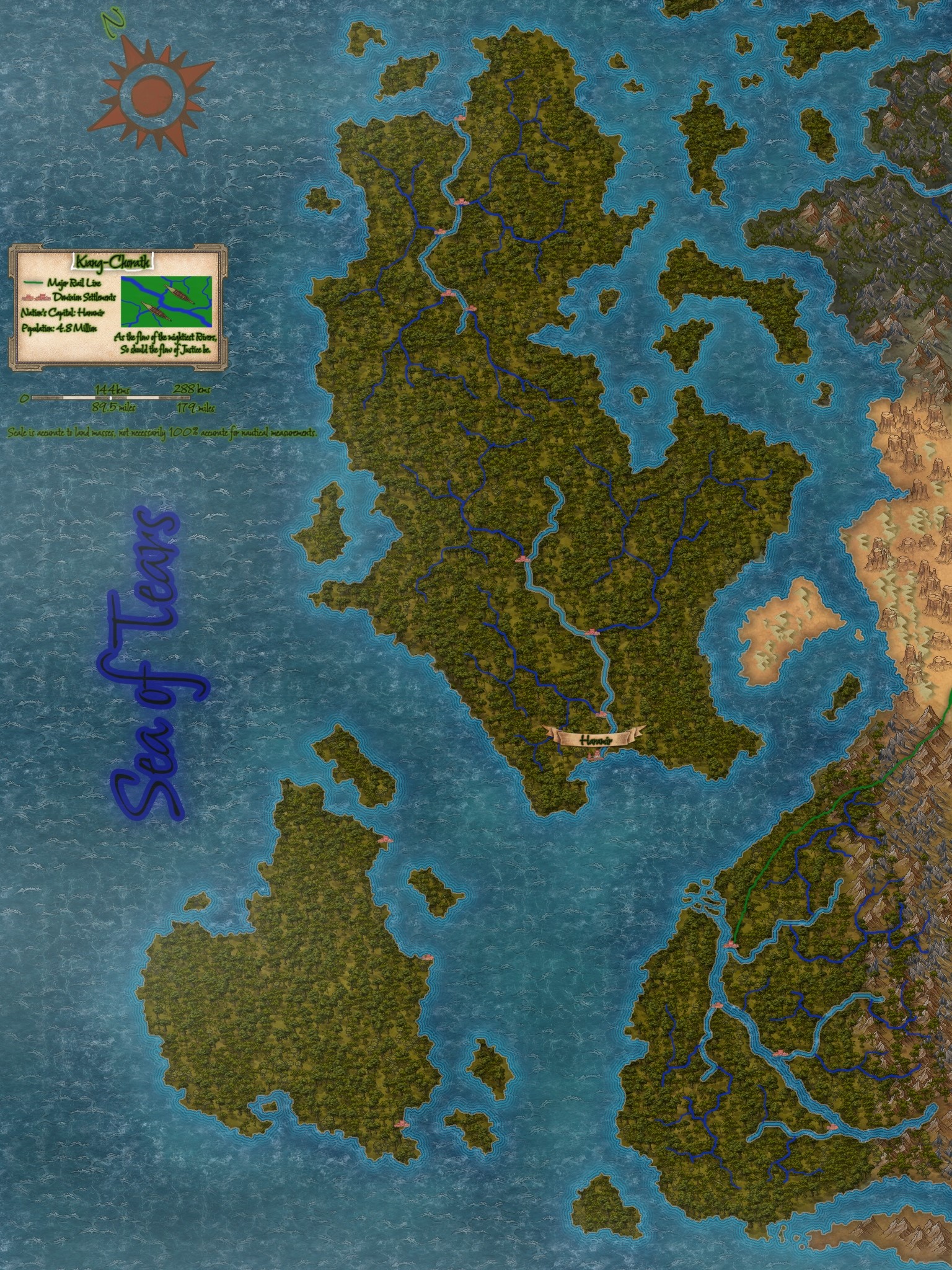
Kang-Chorath, of Jungles and Rivers

To discuss the geography of Kang-Chorath is to of course acknowledge the larger climate zone that is the Chora Jungles. This region is a massive tropical rainforest, however it is far from endless tangled jungle and canopy. The riverlands and floodplains that dominate a large portion of the landscape show tangled everglades and mangrove forests, the upland regions give way to tangled jungles and twisting rainforests. It is a varied climate within that description and though one could be forgiven for at first presuming it is naught but canopy and forest. It is humid, damp, with an near ever present mist. Traveling the waterways of Kang Chorath is an experience beyond description, they are such active environments, with birds flitting and flying overhead, the near constant chatter, calls, and cries of uncountable bird species. Fish of many varieties visible, active, as well as the likes of snakes, crocodilians and marine mammals including the Lotzi River Wolf, a large otter species that roam in packs. It is a busy, veritable and active paradise of flora and fauna, one that cannot help but be noticed even travelling these highly trafficked rivers. Deeper into the jungles are no different, the hoots and hollers of primates of all kinds combining with the drone of insects and birdsong to create a constant rhythm and tempo, a music that surrounds you. There is not true 'silence' within the Chora.

Thus, I seek to prepare you, to give you a small tour, to give you an idea what to expect based upon notable geographic regions that are within the nation of Kang-Chorath.

Geography

The nation of Kang-Chorath is a society and people built upon a naval lifestyle, working with the geography of their region, living in harmony with the coastal regions, the heavy river systems and wetlands. Travel upon the water, the river systems are super highways of the wildlife in this vast and active biome, and thus, learning from their environment, the peoples follow suit. It is a nation built to harmonize moreso than attempt to dominate, with their geography as best they can. It is truly a majestic locale.

The tropical climate is steady, wet with constant rhythm of rain and monsoons followed by steamy humid periods, back and forth, as if the Chora herself and the shallow reefs and ocean between the major land masses of the region are breathing. However to discuss the Chora and its tangled and overlapping ecosystems would require a level of expertise that is better left to a proper naturalist, but for now I shall at least introduce you some of the more notable locales within Kang-Chorath, and some of the most important and informative geographic features.

Maps

  • Kang-Chorath, the Floodplains
Type
Forest, Jungle (Tropical)
Owning Organization

Lotzi River and Basin


The Lotzi river is the largest of the three major rivers in Kang-Chorath, the three 'arteries' of life itself. All life in the Chora Jungles is predicated upon and radiates around these flowing water systems and the Chorathian People are no different. The Lotzi is the largest river on Valerick by width, though not the longest of course. It is a deep, moderately paced river, an absolutely massive volume of water traveling along it. It might be by volume of water the largest river system on the planet but that is a tough thing to be sure of, naturally. The Lotzi basin is thick and overgrown, with the tributary systems that feed the Lotzi itself coming from wetlands and higher coastal regions as well as from the foothills and tangled forests in near the Symphonious Peaks.


The Saltie Flats, whilst in truth arguably covering all of the Lotzi basin, or at least its northern half, is most well described as the northern wetlands and riverlands of the Lotzi and the first tributaries near the coast as well as the delta itself, and the surrounding mangrove forests. These are the breeding grounds of Salt-spine Crocodiles, one of the most dangerous, deadly and dominant predators across all of Kang-Chorath. This unique feature, and yearly rhythm of highly dangerous apex predators congregating en masse for nearly three months of the year every year marks this region out from the rest of the Lotzi Basin.

The Twist-Lash Glades


The smaller island of Holoru is heavily overgrown, violently so it would seem. Little is truly known about the inner regions of this island so vicious is the jungle overgrowth. It seems almost hostile, forceful, the plant life not merely overgrown but oft with barbs, hooks, venomous spines and more upon them. It is a truly hostile environment with many stories, tall tales and local legends surrounding it. Few are those whom have ever entered the region and fewer still are those whom have returned from inland expeditions, though those that do speak both of dangerous beasts of unique and varied description as well as foul beings of maw and claw with skin like armor. Some tell of truly ancient and overgrown structures, perhaps remnants from even before the Sundering, though information is highly limited.

Banoru River


The Banoru River is the fastest of the three major rivers, and the most wide spanning basin and system in terms of land area covered of the three. The Banoru basin covers the southern half of the island of Hamiru almost entirely, smaller tributaries and feeders leeching from the wetlands and jungles, fed by the consistent rains. The faster currents of the Banoru limit its biodiversity somewhat, though far less than some might expect and the surrounding jungle and wetlands are extremely biodiverse. There are some truly unique features within this basin, from and this river system is the most heavily populated part of the country, with the capital, Haramir, sitting at the coast, where the Banoru meats the Sea of Tears.

The Sandleaf Corridor


These busy trade waters are heavily patrolled in unison by both the Chorathians and the Susman navy, a mutualistic agreement between the two peoples to defend what is a key interest. The shallow and warm waters, many reefs and islands, and calmer seas make this corridor both ideal for trade thoroughfares, seeing heavy shipping traffic, and nearer to the many landmasses, though away from the larger port settlements they also offer excellent fishing.

Yuris River


The Yuris River is the slowest moving of the three major arteries of Chorath, as the three rivers are known and the basin and the many tributaries of the Yuris offer a plethora of natural resources and benefits to the Chorathian peoples. Fertile wetlands for agriculture, fantastic fishing and trapping grounds as well as the obvious benefits of these natural veins of shipping and travel of which they are masters.

Comments

Please Login in order to comment!
Dec 1, 2025 19:14 by Dr Emily Vair-Turnbull

Can I visit the Saltie Flats, but in like a mobile shark cage? :D

Emy x
Explore Etrea | WorldEmber 2025