Ledrost Bay
Pronunciation: LED-rost
Map Index: A-4, B-4
Location: Northwest coastal Aorlan
Description: The vast enormity of Ledrost Bay dominates northwestern Aorlan as it runs approximately 230 miles north to south and averages around 50 to 75 miles in width, east to west. Most of the bay exceeds depths of 500 feet, with the exception being the northernmost area where depths run less than 50 feet. The bay remains ice covered for approximately 9 months each year.
Primary Population: None
Secondary Population: None
Minor Population: None
Water Characteristics: The water of Ledrost Bay is saline during the winter months but becomes more brackish during the summer months when large amounts of fresh melt-water enter the bay.
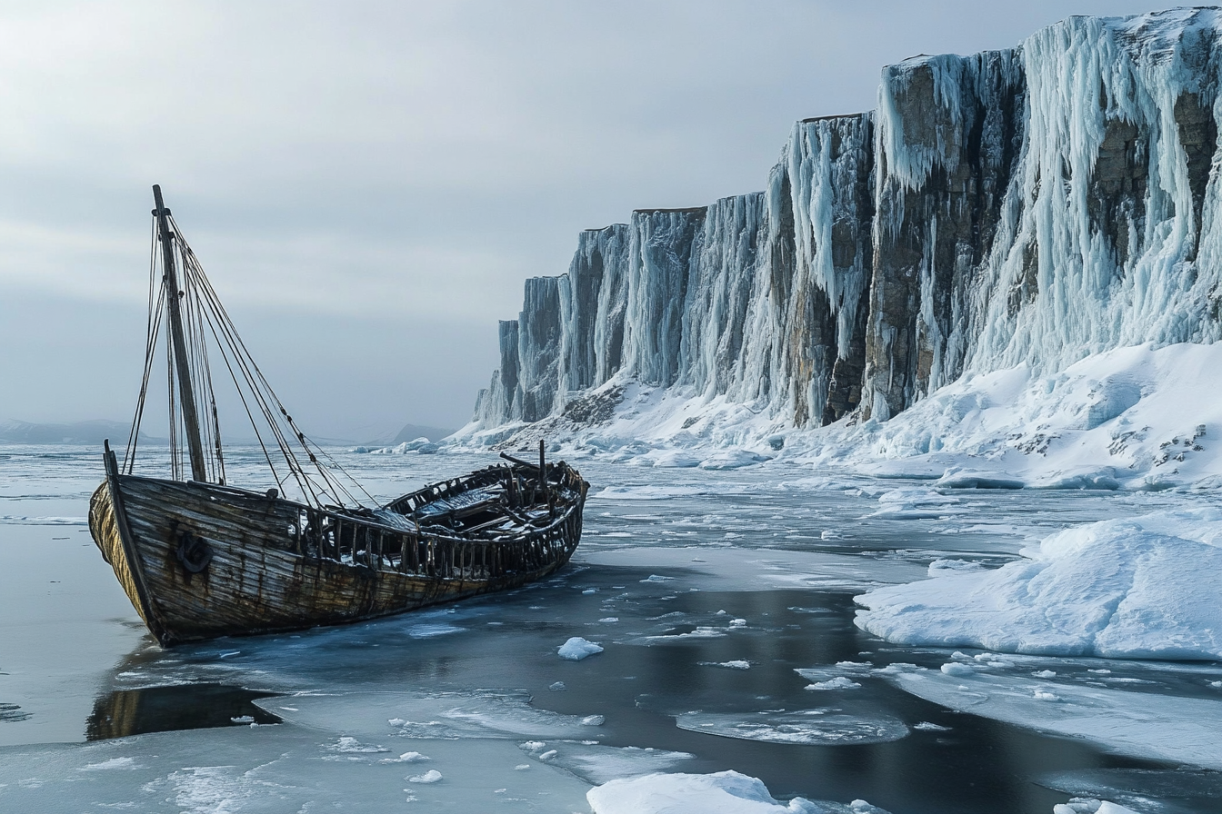
Geography and Geology: Although enormous, where the bay meets the Sea of Ice, the passage narrows to less than 10 miles wide. Numerous rocky islands and hard-to-see reefs make navigating this passage difficult. On either side of this passage, unforgiving sharp rocky cliffs plunge into the bay. This entry passage may only be safely passable by ships for a few months each summer, as winter arrives early. In winter the bay freezes over entirely, often reaching 10 feet in thickness. This will crush the hull of any ships that unlucky enough to be trapped in the ice of the bay. Bordered by jagged icy cliffs, the bay becomes filled with small drifting icebergs in summer.
Climate and Weather Patterns: The bay lies frozen over for most of the year. The ice begins to melt come springtime and by early summer it begins to break up, allowing ships to enter the frigid waters. While the southern half of the bay becomes ice free by midsummer, the northernmost area thaws last. Unpredictable weather changes by the minute, with mighty storms blowing over the bay with little warning. Even in summer the water is near freezing.
Marine Life: Whales, seals, walrus, polar bears, and mysterious, large jellyfish that glow at night.
Cultural & Historical Significance: Most ships that journey here bring passengers eager to find gold. Tales say that rich deposits of gold lie hidden in the stream sediments east of the bay. Most gold prospectors either pan or set up large sluices. However, while many prospectors have become quite wealthy, not all expeditions have ended well. The shoreline contains several wrecks of ships that stayed too long and became trapped for the winter when the narrow mouth of the bay froze shut. The thick ice then crushed the hulls of their ships leaving the crew stranded in a vast frozen wilderness as winter closed in. There are also tales of frost giants and ice beasts and even ice fiends - but prospectors tend to scoff at the tales. "Heebie jeebies ta keep us from gettin' rich!"
Map Index: A-4, B-4
Location: Northwest coastal Aorlan
Description: The vast enormity of Ledrost Bay dominates northwestern Aorlan as it runs approximately 230 miles north to south and averages around 50 to 75 miles in width, east to west. Most of the bay exceeds depths of 500 feet, with the exception being the northernmost area where depths run less than 50 feet. The bay remains ice covered for approximately 9 months each year.
Primary Population: None
Secondary Population: None
Minor Population: None
Water Characteristics: The water of Ledrost Bay is saline during the winter months but becomes more brackish during the summer months when large amounts of fresh melt-water enter the bay.
Geography and Geology: Although enormous, where the bay meets the Sea of Ice, the passage narrows to less than 10 miles wide. Numerous rocky islands and hard-to-see reefs make navigating this passage difficult. On either side of this passage, unforgiving sharp rocky cliffs plunge into the bay. This entry passage may only be safely passable by ships for a few months each summer, as winter arrives early. In winter the bay freezes over entirely, often reaching 10 feet in thickness. This will crush the hull of any ships that unlucky enough to be trapped in the ice of the bay. Bordered by jagged icy cliffs, the bay becomes filled with small drifting icebergs in summer.
Climate and Weather Patterns: The bay lies frozen over for most of the year. The ice begins to melt come springtime and by early summer it begins to break up, allowing ships to enter the frigid waters. While the southern half of the bay becomes ice free by midsummer, the northernmost area thaws last. Unpredictable weather changes by the minute, with mighty storms blowing over the bay with little warning. Even in summer the water is near freezing.
Marine Life: Whales, seals, walrus, polar bears, and mysterious, large jellyfish that glow at night.
Cultural & Historical Significance: Most ships that journey here bring passengers eager to find gold. Tales say that rich deposits of gold lie hidden in the stream sediments east of the bay. Most gold prospectors either pan or set up large sluices. However, while many prospectors have become quite wealthy, not all expeditions have ended well. The shoreline contains several wrecks of ships that stayed too long and became trapped for the winter when the narrow mouth of the bay froze shut. The thick ice then crushed the hulls of their ships leaving the crew stranded in a vast frozen wilderness as winter closed in. There are also tales of frost giants and ice beasts and even ice fiends - but prospectors tend to scoff at the tales. "Heebie jeebies ta keep us from gettin' rich!"